ގަން އިންޓަނޭޝަނަލް އެއަރޕޯރޓް
Appearance
(މިސްރާބުކުރެވުނީ Gan International Airport އިން)
| Gan International Airport ގަން ބައިނަލްއަޤްވާމީ ވައިގެބަނދަރު | |||||||||||
|---|---|---|---|---|---|---|---|---|---|---|---|
 | |||||||||||
| IATA: GAN – ICAO: VRMG | |||||||||||
| ޚުލާސާ | |||||||||||
| Airport type | Public | ||||||||||
| Owner/Operator | Addu International Airport Pvt Ltd. | ||||||||||
| Serves | Addu City, Maldives | ||||||||||
| Location | Gan, Addu City | ||||||||||
| Elevation AMSL | 6 ft / 2 m | ||||||||||
| Coordinates | 00°41′36″S 073°09′20″E / 0.69333°S 73.15556°E | ||||||||||
| Website | GanAirport.com | ||||||||||
| Maps | |||||||||||
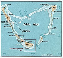
 Map of Addu Atoll showing Gan and airfield | |||||||||||
| Script error: The function "main" does not exist.Location in Maldives | |||||||||||
| Runways | |||||||||||
| |||||||||||
ގަން އިންޓަނޭޝަނަލް އެއަރޕޯރޓް އަކީ އައްޑު އަތޮޅު ގަމުގައި އޮންނަ ވައިގެ ބަނދަރެކެވެ. މި ވައިގެ ބަނދަރު އެންމެ ފުރަތަމަ ބިނާ ކުރީ އާރް.އޭ.އެފް ގެ ގޮތުގައި އިނގިރޭސި ޝާހީ ވައިގެ ބާރުންނެވެ. މިވައިގެ ބަނދަރު ދެވަނަ ބޮޑު ހަނގުރާމަ އާއި 1970ގެ އަހަރުތަކުގައި ބޭނުން ކުރެވުނެވެ. އެހެންނަމަވެސް ފަހުން އިނގިރޭސީން ރާއްޖެ އިން ފޭބީ މި ވައިގެ ބަނދަރު ސަރުކާރާއި ހަވާލު ކުރުމަށްފަހު އެވެ. 2000ގެ އަހަރުތަކުގައި މި ވައިގެ ބަނދަރު ބައިނަލްއަޤްވާމީ ފެންވަރަށް ހެދި ބައިނަލްއަޤްވާމީ ވައިގެ ބަނދަރަކަށް ހެދުމުގެ މަސައްކަތް ފެށުނެވެ.
އިތުރު ފާލަންތައް
[އުނިއިތުރު ގެންނަވާ]- މޯލްޑިވްސް އެއަރޕޯރޓްސް ކޮމްޕެނީ.
- World Aero Data airport information for VRMG
- ↑ Airport information for VRMG from DAFIF (effective October 2006)
- ↑ ފަންވަތް:GCM
