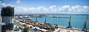
Durrës
Appearance
ދުރްރެސް | |||
|---|---|---|---|
މުނިސިޕަލްޓީ އަދި ޝަހަރު | |||
|
Clockwise from top: Panorama of Durrës, Mosaics at a Basilica within the Amphitheatre, Venetian Tower, Albanian College, Church of Saint Asti and Apostle Paul, Ancient Walls, Amphitheatre, Iliria Square. | |||
| |||
| Script error: The function "main" does not exist. | |||
| Coordinates: 41°18′48″N 19°26′45″E / 41.31333°N 19.44583°E | |||
| ޤައުމު | އަލްބޭނިއާ | ||
| Region | އުތުރު އަލްބޭނިޔާ | ||
| County | ދުރްރެސް | ||
| Founded | 7th century BC | ||
| ސަރުކާރު | |||
| • Type | Mayor–council | ||
| • Body | Durrës Municipal Council | ||
| • Mayor | އެމިރިޔާނާ ސަކޯ (PS) | ||
| ބޮޑުމިން | |||
| • Municipality | 338.30 km2 (130.62 sq mi) | ||
| Elevation | 0 m (0 ft) | ||
| އާބާދީ (2011) | |||
| • Municipality | 175,110[lower-alpha 1] | ||
| • Municipality density | 517/km2 (1,340/sq mi) | ||
| • Administrative unit | 113,249[lower-alpha 2] | ||
| ފަންވަތް:Pluralize from text | Durrsak(e) (Albanian)ފަންވަތް:Pluralize from text | ||
| Time zone | UTC+01:00 (CET) | ||
| • Summer (DST) | UTC+02:00 (CEST) | ||
| Postal code | 2000 | ||
| Area code | +355 (0) 52 | ||
| Seaport | ދުރްރެސްގެ ބަނދަރު | ||
| Highways | |||
| Website | Durrës.gov.al | ||
Cite error: <ref> tags exist for a group named "lower-alpha", but no corresponding <references group="lower-alpha"/> tag was found


