
ފައިލު:Haa Alif Atoll.png

Size of this preview: 366 × 599 pixels. Other resolutions: 146 × 240 pixels | 293 × 480 pixels | 469 × 768 pixels | 625 × 1,024 pixels | 1,305 × 2,136 pixels.
Original file (1,305 × 2,136 pixels, file size: 78 KB, MIME type: image/png)
ހުލާސާ
| Description |
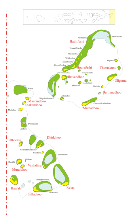
Map of w:Haa_Alif_Atoll Map originally vector'ed by Hassan Waheed, Aabaadhuge of Thinadhoo island. Note: This section of map was extracted and its text was romanized by Oblivious. Special assitance by Waddey and Zuru Converted to PNG by helix84 |
| ތާރީހް | |
| މަސްދަރު |
|
| Author | helix84 |
| ހުއްދަ (Reusing this file) |
GFDL content from English Wikipedia |
| This file is licensed under the Creative Commons Attribution-Share Alike 3.0 Unported license. Subject to disclaimers. | ||
| ||
| This licensing tag was added to this file as part of the GFDL licensing update. |

|
Permission is granted to copy, distribute and/or modify this document under the terms of the GNU Free Documentation License, Version 1.2 or any later version published by the Free Software Foundation; with no Invariant Sections, no Front-Cover Texts, and no Back-Cover Texts. A copy of the license is included in the section entitled GNU Free Documentation License. Subject to disclaimers. |
ޞަފްޙާގެ ތާރީޚް
Click on a date/time to view the file as it appeared at that time.
| ތާރީޚް/ގަޑި | ތަމްބްނެއިލް | Dimensions | މެމްބަރު | ޚިޔާލު | |
|---|---|---|---|---|---|
| މިހާރު | 00:32, 1 ޖޫން 2013 | | 1,305 × 2,136 (78 KB) | Denniss | Reverted to version as of 10:49, 21 February 2007 |
| 21:00, 31 މެއި 2013 |  | 2,136 × 1,305 (87 KB) | Rotatebot | Bot: Image rotated by 270° | |
| 15:49, 21 ފެބްރުއަރީ 2007 |  | 1,305 × 2,136 (78 KB) | Editor at Large | Losslessly rotated image by 90° | |
| 04:05, 29 އޮކްޓޫބަރު 2006 |  | 2,136 × 1,305 (84 KB) | Helix84 | {{Information |Description=== Summary == Map of w:Haa_Alif_Atoll Map originally vector'ed by Hassan Waheed, Aabaadhuge of Thinadhoo island. '''''Note:''' This section of map was extracted and its text was romanized by [[:en:User:Oblivious|Oblivious] |
ފާލަންތައް
There are no pages that use this file.
Global file usage
The following other wikis use this file:
- Usage on bn.wikipedia.org
- Usage on ceb.wikipedia.org
- Usage on cs.wikipedia.org
- Usage on de.wikipedia.org
- Usage on fr.wikipedia.org
- Usage on he.wikipedia.org
- Usage on it.wikipedia.org
- Usage on ko.wikipedia.org
- Usage on nl.wikipedia.org
- Haa Alif-atol
- Gaamathikulhudhoo
- Madulu
- Berinmadhoo
- Alidhuffarufinolhu
- Beenaafushi
- Dhonakulhi
- Dhigufaruhuraa
- Dhapparuhuraa
- Dhapparu
- Kudafinolhu (Haa Alif-atol)
- Gallandhoo
- Maafahi
- Velifinolhu
- Ungulifinolhu
- Umaraiffinolhu
- Naridhoo
- Mulidhoo
- Medhafushi (Haa Alif-atol)
- Matheerah
- Manafaru
- Maafinolhu
- Innafinolhu
- Huvahandhoo (Haa Alif-atol)
- Hathifushi (Haa Alif-atol)
- Govvaafushi (Haa Alif-atol)
- Ihavandhippolhu-atol
- Gaafushi
- Usage on pl.wikipedia.org
- Usage on ru.wikipedia.org
- Usage on sk.wikipedia.org
- Usage on www.wikidata.org